My Vacation Out West
From May 5th to May 27th, I went on a vacation with my parents and my brother that started in the Bay Area and moved all the way to the canyon areas in Arizona and Utah and ended in Las Vegas. Here are brief descriptions of the things we did and what I thought about them.
Bay Area
We spent three days in San Francisco. We split our time between exploring downtown and visiting the various parks and recreation areas in the surrounding area.
Fisherman’s Wharf
Fisherman’s Wharf is a tourist area on the bay in downtown San Francisco. It has a lot of restaurants, street performers, and other things. Getting to see the downtown bay area of San Francisco was interesting. On the other hand, I did not enjoy the amount of people or the lack of anything actually interesting to do. Walking back into the city to get dinner took us away from the wharf area and the tourists there, which was nice.
Golden Gate Park
The Golden Gate Park is a park in downtown San Francisco that stretches from the center of the penninsula all the way to the Pacific coast. It has various sub-gardens for people with specific interests. We went to the Japanese Tea Garden and enjoyed it a lot. After visiting that, we walked all the way to the beach. The beach itself was almost too windy to enjoy, but it was definitely impressive.

Presidio
The Presidio is an area surrounding the San Francisco side of the Golden Gate Bridge. It most notably contains an old military base/outpost that belonged to somebody. We didn’t actually do that much in the Presidio, besides get to the coast to get a nice view of the Golden Gate Bridge. The base area did look interesting, but nearly everything was closed by the time we got there. The view of the Golden Gate Bridge was striking, but my attention was focused more on the bay and the general landscape and city layout rather than the bridge.
Muir Beach Overlook and Muir Woods
Across the Golden Gate Bridge is the Golden Gate Bridge Recreation Area, which contains several towns and also interesting park-like areas. Above a town called Muir Beach is an overlook which features a great view of the Pacific Ocean as well as the California Pacific coastline landscape. Further inland, there is a large grove of Coastal Sequoia trees called Muir Woods. These Sequoia trees are rare these days, so a grove like this is pretty special. We intended to visit Muir Woods in the morning, but when we got there it was already full. So we went on to Muir Beach instead. The overlook gave me the taste of the Pacific that the beach in Golden Gate Park was unable to. Going back, we were able to get into Muir Woods and walk around for a while. Hiking up alongside the grove allowed me to really appreciate how tall the trees really are. There is still much in the recreation area that I would like to check out. I think the bay area is fortunate to have such a wonderful, activity-rich natural landscape so close by.
Tiberon
Tiberon is a town on the bay across from San Francisco. The promenade here features a stunning view of the San Francisco skyline. The houses here are also all quite beautiful, adopting mostly sleek, modern, yet modest styles (unlike the homes in the SF hills). Getting to see the sunset from here was a fantastic way to end my favorite day in San Francisco.
The Big SF Hill
I don’t know how better to describe this area than as a big hill in the middle of downtown San Francisco. This part of downtown San Francisco features various squares and small parks, the iconic San Francisco cable cars, and lots of very steep streets. Walking around this area was interesting. We did not ride the cable cars, nor did it look like something I would enjoy. I enjoyed the small, scattered downtown parks the most. I could see myself coming here to study on nice days if I went to school in the area.
Chinatown
Chinatown is also situated on the “big SF hill”, but deserves its own treatment. It is mostly just an assortment of stores and restaurants that generally have mostly Chinese things. For some reason, I was expecting something more like a Chinese microtown in downtown San Francisco and not some tourist attraction meant to sell cheap trinkets to people looking for souvenirs. The Chinatown Culture Center was very close to what I imagined the whole of Chinatown would be like. It was nice seeing the generations of people living here all spending their time together in this open area.
Overall, the actual city parts of San Francisco disappointed me, while the parks and surrounding area impressed me. I was also surprised at how young the working population of San Francisco really is. We were walking to get dinner at around 5pm on a work day, and it was amazing to see all the people roughly my age walking around to get some dinner or make their way to public transportation.
Yosemite
We then spent three days in/outside Yosemite National Park. Each day featured one substantial hike accompanied with a lot of marveling the sights and the general massiveness of the Yosemite Valley landscape.
Mirror Lake Trail
This trail starts at the northeast end of Yosemite Valley and walks along the Tenaya River up to and past Mirror Lake. The whole path takes place under the flat face of the iconic Half Dome. This hike was perhaps a good introduction to what would become two and a half weeks of intermittent intermediate-tier hikes. It was mostly flat, but quite scenic with some nice views of the river and the lake and especially good views of the Half Dome on the return loop of the trip. Due to the wet winter California experienced, significant portions of the trail in the upper half were flooded to the point that it made more sense to wade through them barefoot than to try to climb and jump around in an attempt to stay dry.
Lower and Upper Yosemite Falls
There are separate trails leading to the Lower and Upper Yosemite Falls. The trail to the lower fall is incredibly accessible and doesn’t even merit mentioning. It was nice to see, but hardly an experience. The Upper Yosemite Falls trail goes up roughly 350 meters to an overlook where you can see the Upper Yosemite Falls in all their glory. Following the trail further takes you to the top of the falls. My brother and I went about two thirds of the way up to the top of falls from the overlook, but time constraints we had placed on ourselves prevented us from making the full hike. The trail is quite fun, and the view you get of the falls and of the valley along the way are definitely worth it. However, it is not the easiest, and there are many segments with sand on smoothly eroded stone that can be difficult and dangerous.
Mist Trail and John Muir Trail
The Mist Trail and John Muir Trail loop takes the hiker directly past the Vernal Falls and also gives them views of the Nevada Falls and the round part of Half Dome. Initially, our plan was to just walk the Mist Trail up and down because the John Muir Trail seemed too long for our liking, but we underestimated exactly how wet we would get from the spray coming from Vernal Falls on the way up. This state of being soaked combined with coolness of the cloudy day forced us into walking the John Muir Trail back down. This turned out to be fine and probably a lot safer. We got fantastic views of the upper valley, with the mountain peaks, waterfalls, and interleaved clouds. The John Muir Trail is quite a bit longer and also goes up to a point above Vernal Falls which would not have been necessary for what we had planned. I would recommend to people looking to walk the Mist Trail to bring a change of clothes in a waterproof bag. The falls will soak you through your raincoat and if you are poorly prepared you might end up in a lot worse shape than I did. I fortunately escaped without getting sick, but had it been any colder, windier, or wetter, I would have probably needed to take a couple days to recover.
Yosemite is an incredible place and the main thing detracting from that is how big of a tourist attraction it is. There are so many people there, even in the off-season. And the more accessible parts of the park are swarming with people that have no idea what they are doing, why they are there, or why it even matters. I think Yosemite would benefit from an approach similar to Zion Canyon, where all visitors park at the beginning of the main attraction (Yosemite Valley) and take park service shuttles to various attractions. This is unfeasible for a couple reasons in Yosemite’s case, the main one being, there is nowhere near the valley to park the number of people that Yosemite currently serves (or even a significant fraction of them). It still pains me to know that the most magestic of the USA’s parks all suffer from this overcrowding problem, where the noise and activity distract the visitor from the magnitude and greatness of the natural wonder in front of them. Honestly, how are you supposed to feel awe when you have a basic white girl talking about her ‘gram on your left, a rich, old Australian complaining about how they aren’t meeting their schedule behind you, and a choir of babies crying directly to your right?
Mono Lake
Mono Lake is a salt lake located east of Yosemite National Park. It has no outlets, so its level is the result of an equilibrium of evaporative processes and inflows from nearby mountains. It is the site of a significant restorative effort after water was diverted from the basin to be used in Los Angeles tap water. It was interesting to see the evolution of the lake overtime and especially to see the lasting positive impact appropriate necessary legal action had on the area. There were also so few people there, which left me with a profound sense of isolation.
Death Valley
We only spent one day in Death Valley, but we did so much and I was so impressed by this almost otherworldly landscape that I think it merits being treated separately like Yosemite and San Francisco.
Dante’s View
Dante’s View is a mountaintop outlook with some short paths that looks over the Badwater Basin and many other iconic Death Valley features. It gives an excellent view of the landscape past Death Valley in all directions. This view is what is truly spectacular because the air is so dry there that you can actually see clearly quite far away. The outlook is accessible via car and the paths are wide and easy to hike. I would recommend this outlook to anybody that can afford a two hour detour on their path through Death Valley.
Artist’s Drive
Like much of the Southwest, the landscape formations in Death Valley often feature heavily tilted plates which reveal the various layers of rock associated with different ages when those minerals were deposited. Artist’s Drive is a road that twists and dips through the foothills in front of a mountain. The entire terrain is as I described above, but notably all of the layers here have unique metals or minerals in them that paint the landscape in many different colors. It feels sometimes like you are no longer on Earth, the landscape is so weird.
Badwater Basin
Badwater Basin is perhaps the most obvious Death Valley attraction. It is a great salt deposit in the middle of the valley. It occurs around the lowest point in the basin, making it a huge attraction to Death Valley visitors. There is a path to walk out onto the basin, which is a great experience. We were out there at about 2:00 pm, so it was quite hot. One thing that is not really mentioned about Death Valley is that the heat actually is mitigated a little by the incredible dryness and the ever present wind in the valley. It was the dryness of the air that was really surprising for me. Every bead of sweat just immediately got pulled into the air because it is so water-starved.
I didn’t touch much on how alien the landscape, vegetation, and climate of Death Valley is, but it really is so strange. The landscape shifts from sand dunes to bush fields to desert with no vegetation to a literal lake of salt. The mountains, the vast expanses with just nothing, the relatively few tourists all leave you feeling that you might truly just be somewhere completely different.
Utah and Arizona Canyons
Between Death Valley and a final stay in Las Vegas, we traveled through the incredibly varied canyon region in the middle of the southwest, mostly Utah and Arizona.
Zion Canyon
Our time in Zion Canyon was only limited to half a day, but that alone was enough to impress me. Zion Canyon is structured so that all visitors attempting to enter the scenic portion of the canyon, the main attraction, need to park at the beginning of the national park and take the park’s internal shuttle service up and down the canyon. This is an excellent system. It lowers congestion up-canyon from people driving and taking pictures and it isolates the parking problem to the part of the park where parking is available everywhere. Taking the shuttle, we visited several stops walking between some of them along the riverbank. There were also two hikes we did: the first was up to Weeping Rock, which is a mountainside where water comes out along some harder rock layer and a hanging garden is formed where this stream offers sufficient moisture; the second hike was up to the emerald pools. This hike offered great views of the general canyon layout. The pools were nice, but they definitely took a backseat to the view out into the canyon. We did not get to hike up to Angel’s Landing due to time constraints, but I plan on doing this when I return. Zion Canyon impressed me, so much so that I would consider it one of my top two favorite things on the trip.
Kolob Canyon
On the other half of Zion Canyon National Park, there is another canyon called Kolob Canyon. It is a bit less impressive in terms of the rock walls and the stream flowing through is much less impressive, so it attracts fewer people, but that is one of its charms. While here, we hiked the Taylor Creek Trail, which takes you up the canyon along the Taylor Creek up to a hollow of sorts. This hike was incredibly scenic and peaceful. There were so few people here it was actually possible to feel isolated. While not as impressive as Zion, the rock formations here were still quite impressive, and it was one of the few locations I really felt compelled to take out my phone and take a couple pictures.


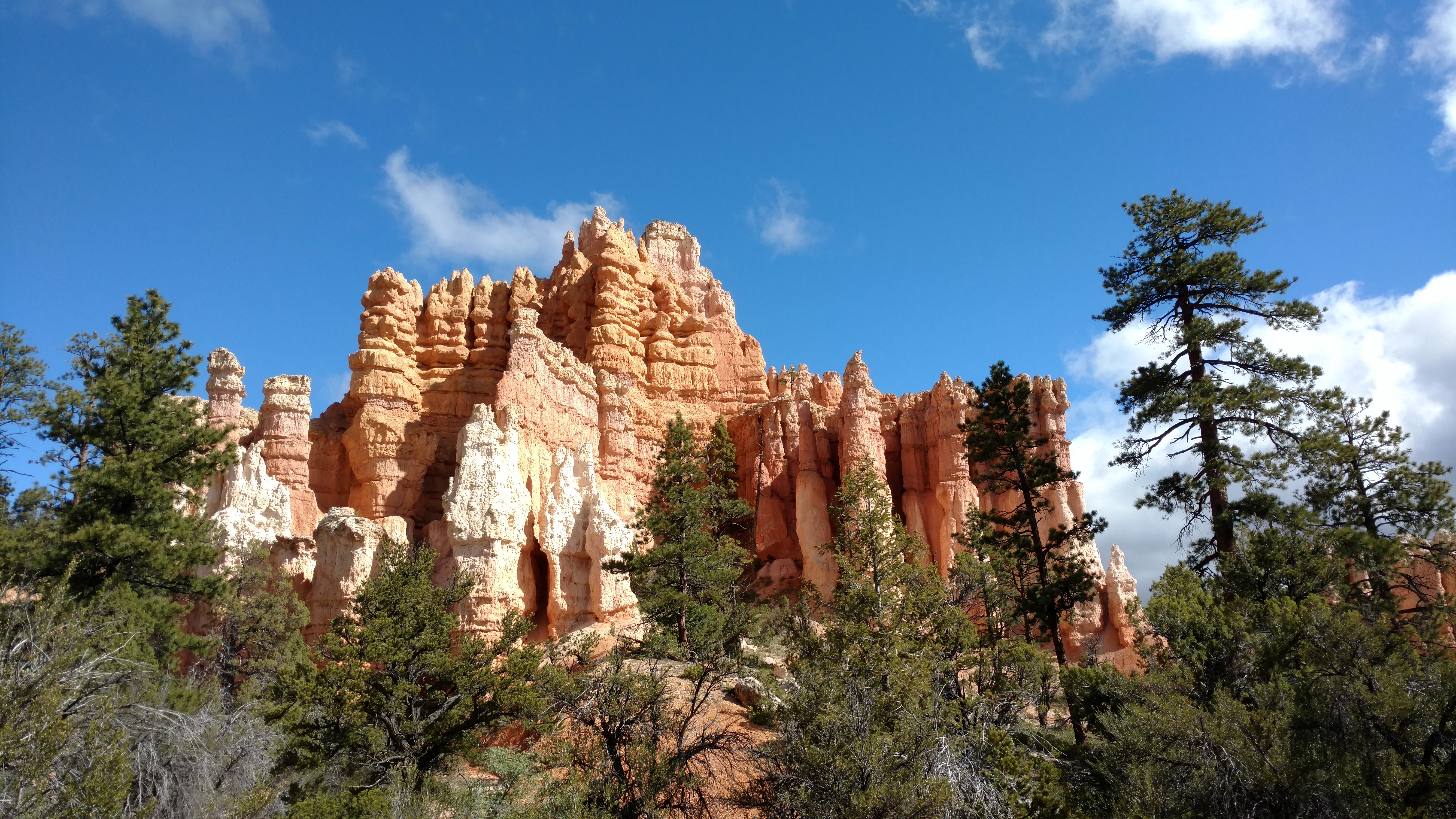
Bryce Canyon
Bryce Canyon might be the second most iconic southwestern canyon, following the Grand Canyon, of course. And it lives up to its reputation. The amphitheatre part of the park is well shuttled, but to get out along the extended road to Rainbow Point, you have no choice but to drive. This drive along the rim is filled with many scenic views, not only of the incredible rock formations, but the general land layout of the Grand Staircase area. The spires give way to trees and shrubs, which in turn give way to vast expanses of dry desert land.
The highlight of my time in Bryce was not the rim views or even the area around the amphitheatre. It was the Fairyland Trail hike which takes you down into the canyon and around the Boat Mesa. It is a relatively long trail and it takes you up and down a bit, but it is not technically difficult by any means. It is also much less crowded than the amphitheatre, which allows for the atmosphere to really sink in. What I mean by the atmosphere is the sense of being somewhere completely foreign. You get the sense that you might as well be on Mars with how incredible the landscape is here. The spires, the rounded canyon and mesa walls, the vegetation, the idea of the water just slowly receding and flowing to create this place makes for a great hike. This contends with Zion Canyon for my favorite experience on the trip.

Grand Staircase
In between visits to Bryce, we also went to the Grand Staircase-Escalante National Monument. I believe this is a bit of a misnomer, because the Grand Staircase is really the entire uplifted plateau and the various layers that show after erosion and the different environments that exist on them. While we were there, we went on a short roundtrip hike around Shakespeare Arch. It was a good choice for the weather that day (it was rainy and fairly cold), and it was interesting to experience the clay soil that clearly exists in its current form at the mercy of the rains. The arch itself was also cool, but really the point of interest was the greater landscape. Scattered throughout the rest of the national monument were other bizarre land formations. While I would not really consider this park to be very essential to the Southwest experience, it was not busy at all when I visited, and that remoteness and isolation is a quality I very much enjoyed.
Slot Canyons
Next, we visited a set of slot canyons. Slot canyons are effectively narrow, shallow ravines carved into an otherwise fairly flat landscape. The drive to the slot canyon involved an hour of driving on a dirt road through this incredibly flat plateau. All of a sudden, the landscape just dips 50 meters and there are very narrow hallways carved into the rocks. We visited Peek-a-Boo Canyon with the intention of walking from the top of Peek-a-Boo to another nearby slot canyon, Spooky. However, people had warned that the path between the two was difficult to find and follow, and sure enough, after searching for roughly two hours, we decided it would be better to just go back down Peek-a-Boo. The slot canyon itself was remarkable, the forms of the rock, from the bottom to the top, tell stories of wild water flows that formed these sometimes smooth and sometimes eerily jagged formations. Peek-a-Boo is fairly accessible and I can’t imagine most people feeling too cramped. Spooky was supposed to be quite a bit narrower, perhaps too narrow to navigate through.
Canyonlands
Near Moab, there are two significant attractions, Canyonlands National Park and Arches National Park. Due to how full Arches was likely to be, the choice was made to go to Canyonlands. The main attraction of Canyonlands is situated atop an extended plateau or mesa. From here, you can see down through many layers of the rock. And there are at least two distinct lower levels in the landscape before at the very bottom you reach the river that carved it out. I think Canyonlands was particularly impressive because it showed the vast amount of space in the landscape, which is something that is hard to appreciate when you are either looking at flat land with landmarks or flat land with deep narrow cuts made into them. In Canyonlands you see this high rim that encircles a huge amount of land which has inside of it some canyons carved in. Learning about the history from a geologist was also interesting.
Monument Valley
Monument Valley is the “flat land with landmarks” I described earlier. The entire area is in Indian country and so you get this combination of pristine rock formations and odd makeshift settlements. While the jutting rock forms in Monument Valley are beautiful, I don’t have so much to say about the area. It is basically a local basin surrounded by a rim (one step higher in the staircase) and inside the basin remain formations that survived the erosion process that left the rest of the area flattened. To me, the thing that stood out the most here and in a couple later areas was just how the Native Americans live. I am ill poised to talk about this, but the signs of neglect by the rest of the USA were clear, and the waves from this mistreatment long ago were still rippling and could be felt today. It pains me to say this, but I have no idea how Americans could remedy this situation without being insensitive or coming off as trying to bury the culture of this people. These are scenarios where I firmly believe that no level of “wokeness” can put you in a position to remedy all that has gone wrong here (not that I am that progressive). It just seems that the wounds go too deep. To me, the fix would be to aggressively assimilate Native Americans into standard society, so they can feel that they are a part of the greater union and not some separate entity, but this in turn would literally crush the local culture. I can’t think of anything good and so I think my only option is to talk to people that are part of the culture and understand what they want (and what they don’t want).
Lower Antelope Slot Canyon
Still in the Navajo area, we visited the Lower Antelope Slot Canyon. Unlike the remote Peek-a-Boo and Spooky, this canyon is about 10 minutes away from the nearest town. It is managed entirely by the Navajo Nation and access comes in the form of guided tours. My tour was led by a guy named Tyler who seemed to be about my age and made jokes about the various nationalities of the people on the tour the entire time. The canyon itself is impressive: the forms, the lighting, the uncanny resemblance to animals, people, and other things all made for a visually vivid experience. I unfortunately was dealing with the leftover symptoms of a heat stroke, and wasn’t able to fully appreciate what I was seeing. I still enjoyed it a lot and would love to come back again some time.
Grand Canyon Rim
Of course, finally, a trip to the Southwest would not be complete without a visit to the Grand Canyon. I was dreading this the entire trip, because based on the problems I had with Yosemite Valley and Bryce Canyon Rim and the crowds there, the Grand Canyon would be an even bigger problem. To my surprise, the Grand Canyon rim experience was actually quite pleasant. The crowds were there, but well dispersed and it seemed that the entitlement that some people at Yosemite seemed to have wasn’t as present. But as for the canyon itself, it is truly grand. The defining feature is the size, both across the canyon and down the canyon. Much of the sense of space and awe of Canyonlands can be translated to the Grand Canyon, but I’d like to emphasize the differences: Canyonlands has large extended open areas on intermediate levels while the Grandcanyon is basically a craggy rock face from the top to the bottom with the exception of some leveling out in the middle. Also, the Grand Canyon is much deeper than Canyonlands in terms of height difference, and you really will be hard-pressed to find places in the Grand Canyon where you can see much of the very bottom. A few glimpses of the Colorado River are probably the best you can manage.
Some of the highlights of the rim experience were the sunrise and sunset views of the canyon from various points. We saw the sunset from Hobi Point and the sunrise from Yaki Point. It is interesting to see the way the different lights and colors change how the canyon looks, and you can see it all over the course of half an hour or so. This is perhaps the experience I most strongly recommend, on the rim. Especially if you can manage to wake up early for sunrise, you can see a lot without crowds of people around you. Just bring layers because it is really cold that early in the morning.
Bright Angel Trail
After going to see the sunrise and then eating breakfast, my brother and I went on the Bright Angel Trail. This is perhaps the most accessible trail down into the Grand Canyon, but that does not mean it should be taken lightly. The elevation difference between the rim and Indian Garden, the mid-level destination is roughly 1000m and the path does that in about 5 miles. And you have to climb all of that back up in the late-morning or afternoon heat, which gets up into the 100s in the lower portions of the hike. However, the hike is definitely worth it. Past the first rest stop, there are relatively few people and you are hiking a fairly easy trail that takes you through a variety of different vegetation. If you look up, you see the huge walls with the agave flowers peeking out over the cliff edges. It is a remarkable experience. My brother and I did the roundtrip down to Indian Garden and back in about 5 hours from 7:30 to 12:30. However, it was brutal on the way back up and if I did it another time I would skip the sunrise rim view and start earlier in order to avoid hiking in the mid-day heat. The environmental factors are really not to be underestimated.

Las Vegas
Hilariously, or perhaps appropriately, after nearly three weeks traveling through relatively remote, undisturbed areas, we spent two and half days in Las Vegas before flying out. Las Vegas was about what I expected, mostly people spending copious amounts of money on things and losing even more while gambling. I spent the days walking through the different casinos and seeing how each of them created a microcosm inside to keep visitors inside for as long. Caesar’s Palace was particularly terrible. I think I spent an hour or so trying to find an exit before deciding to just walk back the way I came. The best part of the Las Vegas strip is definitely the water shows in front of hotels like the Bellagio and the Mirage. But having been there once, I don’t think I will go out of my way to go back to Las Vegas again. The gambling and goods-buying life just isn’t for me.
Trip Conclusion
The motivation for this trip was that both my parents had significant ties to the southwest. My mother in particular lived here for some time in her life and accordingly loves this area of the country. This was probably the last time all of us would be able to get three weeks off to do a trip like this (it almost didn’t work for me). But I enjoyed it a lot, and I am so grateful for them organizing this and making sure that I was able to experience something that meant so much to them.